Mapping groundwater-dependent vegetation in temperate climates on the example of Central Germany
Mapping groundwater-dependent vegetation in temperate climates on the example of Central Germany
El-Hokayem, L.; Schulz, D. E.; Conrad, C.
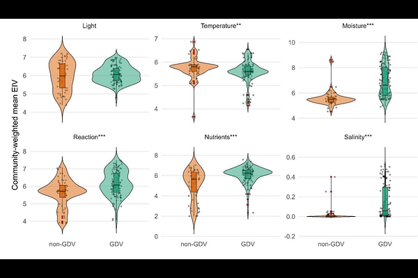
AbstractGroundwater-dependent ecosystems are biodiversity hotspots that provide habitat for specialised species. The EU Water Framework Directive (WFD) stresses the importance of identifying and protecting these ecosystems. However, they remain poorly mapped in temperate regions, as most studies have focused on (semi-) arid regions, where groundwater use by vegetation is both more prevalent and easier to detect from remote sensing. In this study, we transfer mapping approaches for groundwater-dependent vegetation (GDV) from dry climates into a novel framework for humid climates. To do so, we integrated, ECOSTRESS evapotranspiration data, together with high-resolution remote sensing data, regional geospatial data and field data to identify GDV. To test our framework, we trained and validated Random Forest models with eight predictor variables using 166 ground-truth vegetation plots to map GDV in Saxony-Anhalt (Germany). The final model achieved an overall accuracy of 0.97, identifying 2,067 km2 (41%) of GDV. Currently, only 19% are protected under the EU WFD. The proposed mapping framework offers a new solution for identifying GDV in temperate regions. The new GDV maps can contribute to managing groundwater resources and preserving biodiversity hotspots in regions facing increasing droughts, ultimately supporting implementation of the EU WFD.